As an avid traveler and map enthusiast I always get excited when planning trips to new countries. Recently I’ve had my sights set on Turkey. To help me learn more about this captivating country, I turned to some detailed maps of the area. What I found has made me even more eager to book a flight to Istanbul!
In this article, I’ll walk you through some of the key features of Turkey that really stood out to me from looking at maps. My hope is that it’ll inspire you to dig deeper into cartography and geography as a way to explore new parts of the world.
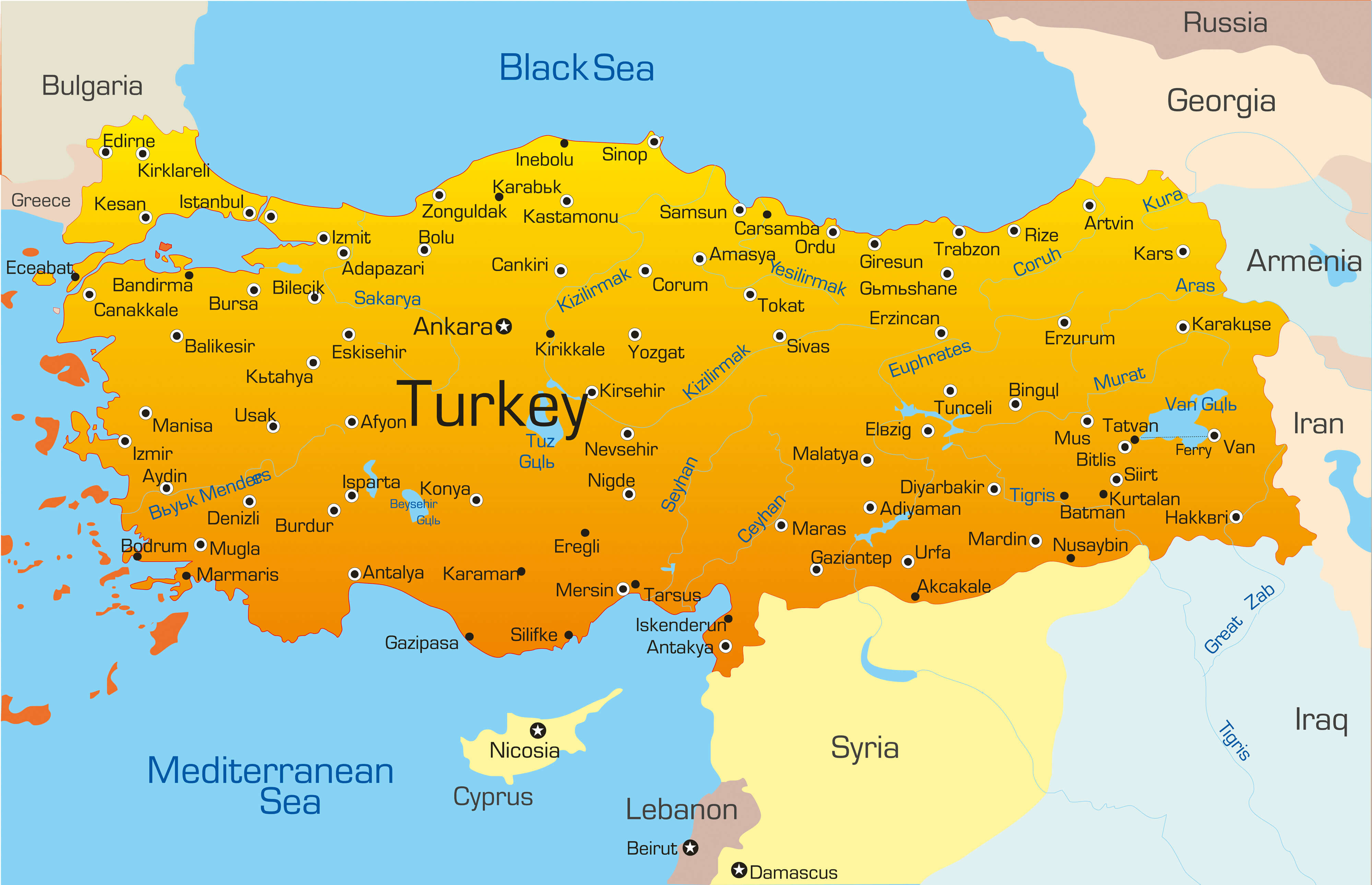
Where Is Turkey Located?
Turkey occupies a unique geographic position, straddling the boundary between Europe and Asia. The country’s territory is spread across the Anatolian peninsula, which forms the westernmost extension of Asia.
When looking at a map, you can see the clear divide between the European and Asian sections. The boundary is formed by the Turkish Straits (the Bosporus and Dardanelles) as well as the Sea of Marmara. Around 3% of Turkey’s land area falls within the European continent.
Turkey shares land borders with eight countries: Greece, Bulgaria, Georgia, Armenia, Iran, Iraq, Syria, and Azerbaijan (the Nakhchivan exclave). Given its strategic location, it’s no surprise Turkey has played such a pivotal role in Eurasian history and trade.
Exploring the Diverse Landscapes
One detail that jumped out to me from the maps is Turkey’s incredible geographic diversity. The landscapes range from fertile coastal plains to arid steppelands to snow-capped mountains.
In the interior lies the Anatolian Plateau, with an average elevation of 3,500 feet Prominent mountain ranges like the Taurus and Pontic cut through the plateau, creating stunning alpine scenery Turkey’s tallest peak is the stratovolcano Mount Ararat, rising 16,854 feet near the Armenian border.
Along the coastlines, you’ll find low-lying plains that are ideal for agriculture. Major rivers like the Tigris, Euphrates, and Kızılırmak help irrigate these fertile areas. Turkey has over 5,000 miles of coastline, so beach vacations are definitely an option too!
The Provinces and Major Cities
Administratively, Turkey is divided into 81 provinces or “iller” in Turkish. Istanbul province is the most populated, thanks to the bustling metropolis of the same name. But Ankara province, located in the country’s interior, is home to the capital and second largest city, Ankara.
Some other highly populated provinces include Izmir (containing Turkey’s third largest city, Izmir), Bursa, Adana, and Gaziantep. Each province has its own unique character, cuisine, and landscape.
When studying the maps, I was intrigued by the location of Istanbul. It straddles both the European and Asian side of the Bosphorus strait, giving it a true East-meets-West character. Exploring this cosmopolitan city should definitely be at the top of my Turkey itinerary.
Interesting Borders and Nearby Countries
Since Turkey occupies such a strategic location, it’s closely surrounded by various countries and bodies of water.
To the northwest, Turkey is bordered by Greece and Bulgaria – both Mediterranean countries and NATO allies. The Black Sea coastline forms the northern border. Here you’ll find cities like Samsun, Trabzon, and the Crimean city of Sinop.
Moving east, Georgia and Armenia border Turkey before reaching the hilly Iran plateau. Southeast lies Iraq and Syria -MESOPOTAMIA – key Middle Eastern nations.
Finally, across the easternmost border is Azerbaijan and the Nakhchivan Autonomous Republic (an exclave of Azerbaijan). Turkey truly lies at the crossroads of Europe and the Middle East!
A Nation with a Complex History
Looking at Turkey’s location and borders on the map, it’s easy to see how this region has witnessed so much history and conflict over the millennia.
The mighty Ottoman Empire ruled these lands for over 600 years, leaving an indelible influence on culture, food, language, and architecture. Ancient conquerors like Alexander the Great cut through Anatolia, linking Europe and Asia. The Republic of Turkey itself was only founded in 1923 after the fall of the Ottoman Empire.
I can’t wait to visit Turkish museums and archaeological sites to appreciate this epic history firsthand. Even in the modern age, Turkey continues to be highly influential in regional politics and economics.
Take Inspiration from Cartography
Maps are an amazing tool for igniting your curiosity about the world. Whether you’re planning a big overseas vacation or just a weekend getaway, spend some time researching the cartography and geography. Trust me, it will get you that much more excited for your travels! Let geography fuel your sense of adventure.
Provinces of Turkey Map
Turkey is divided into 81 provinces (iller, singular – ili) for the sake of proper administration. These provinces are further subdivided into 937 districts and smaller subdivisions. The 81 provinces in alphabetical order are as follows: Adana, Adiyaman, Afyonkarahisar, Agri, Aksaray, Amasya, Ankara, Antalya, Ardahan, Artvin, Aydin, Balikesir, Bartin, Batman, Bayburt, Bilecik, Bingol, Bitlis, Bolu, Burdur, Bursa, Canakkale, Cankiri, Corum, Denizli, Diyarbakir, Duzce, Edirne, Elazig, Erzincan, Erzurum, Eskisehir, Gaziantep, Giresun, Gumushane, Hakkari, Hatay, Igdir, Isparta, Istanbul, Izmir (Smyrna), Kahramanmaras, Karabuk, Karaman, Kars, Kastamonu, Kayseri, Kilis, Kirikkale, Kirklareli, Kirsehir, Kocaeli, Konya, Kutahya, Malatya, Manisa, Mardin, Mersin, Mugla, Mus, Nevsehir, Nigde, Ordu, Osmaniye, Rize, Sakarya, Samsun, Sanliurfa, Siirt, Sinop, Sirnak, Sivas, Tekirdag, Tokat, Trabzon (Trebizond), Tunceli, Usak, Van, Yalova, Yozgat, and Zonguldak.
With an area of 40,813.52 sq. km, Konya is the biggest province of Turkey by area and Istanbul is the most populous one.
Ankara, the capital city of Turkey and the country’s second-largest city is located in the central part of the Anatolian peninsula.
Turkey is a transcontinental Eurasian country. The major part of the country lies in the Anatolian Plateau of Western Asia while a small part is located on Southeastern Europes Balkan Peninsula. The Turkish Straits (Bosphorus and Dardanelles) and Sea of Marmara separate the European part of Turkey called East Thrace from Anatolia. Turkey is located in the Northern and Eastern Hemispheres of the Earth. It is bordered by seven countries: Greece and Bulgaria to the northwest, Georgia to the northeast, Armenia and Iran to the east, Iraq to the southeast, and Syria to the south. Nakhchivan, an exclave of Azerbaijan also borders Turkey to the east. The country has coastlines on the Black Sea to the north Aegean Sea to the west and the Mediterranean Sea to the south.
Turkey Bordering Countries: Greece, Iraq, Georgia, Syria, Bulgaria, Iran, Armenia, Azerbaijan.
Regional Maps: Map of Europe
MAP OF TURKEY
FAQ
What country does Turkey belong to?
What is the famous in Turkey?
Which country is so close to Turkey?
What is the political map of Turkey?
Turkey’s Political Map shows International boundaries, provinces’ boundaries, and the capital city of Turkey, Ankara. Turkey Flag that is currently in use was adopted on 5th June 1936. The Turkish Flag comprises a red background on which there is the motif of the crescent moon and a star.
Where in Turkey is a mountainous region?
In the eastern third of the country, the northern and southern fold systems converge to produce an extensive area of predominantly mountainous terrain, with pockets of relatively level land confined to valleys and enclosed basins, as are found around Malatya, Elazığ, and Muş. City of Afyonkarahisar, Turkey, overlooked by a cone of volcanic rock.
What is the geology of Turkey?
The geology of Turkey is complex, with sedimentary rocks ranging from Paleozoic to Quaternary, numerous intrusions, and extensive areas of volcanic material. Four main regions can be identified: the northern folded zone, the southern folded zone, the central massif, and the Arabian platform.
What is the highest mountain in Turkey?
The highest mountain in Turkey is Ağrı Dağı or Mount Ararat, at 5,137 m (16,854 ft). With an area of 783,562 km², the country is more than twice the size of Germany or slightly smaller than the U.S. states of Texas and Louisiana combined.